Every maintenance shop has one. The one tech that has been there forever and knows where everything is. When it’s time to get out the backhoe he has to survey the dig site to tell you where the water, power and telephone lines are buried because he’s the only one that knows. He knows the sites and buildings inside and out. He’s a wealth of knowledge and you don’t know what you’d do without him. Well, one day you’re gonna find out.
The current alternative to the “all-knowing, all-seeing” tech is a stack of as-built and construction manuals. Most of them are out of date or were not correct to start with. So what do you do? How do you manage all this information and make it easily accessible to the people that need it, when they need it?
If you’ve read our blog in the past you know we use TeamWORKS products and capabilities as real-life examples. This blog is different and is about a specific product. We’ve been looking, since 1998, for a solution to the problem of your one tech that has everything stored in his head and what happens if he leaves. Three companies, hundreds of experts and countless hours of browsing resulted in nothing that was good enough for us to recommend to our current customers. We’ve seen solutions implemented with marginal success but the cost always outweighed the benefits – both the initial cost to implement and the continuing cost to maintain.

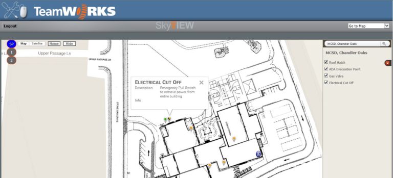
Enter SkyVIEW. SkyVIEW solves these issues at an affordable price and can be maintained by the customer. So let us describe the solution. The idea is to give the user as much information as possible as quickly as possible. The best way to do that is with pictures. TeamWORKS SkyVIEW uses a base map (Google Maps) as the backdrop. You can then insert images, CAD drawings, as-built specs or whatever image you would like to attach to a building on top of that map so you can see how your site fits in the world around you. You can turn it on or off and view it on aerial views or street maps. That alone puts these drawings into a whole other view, making them more useful than ever. You can also load floor plans. Zoom in and out, pan around and basically make your CAD drawings available to your users via a web browser.
With SkyVIEW, you have the ability to zoom into a school, turn on site and floor plans and see details.
Pretty cool and fairly useful, but here’s where the magic occurs.
If you’ve ever searched for a restaurant online you know the results are a map with markers on it to pinpoint the various restaurants. When you click on a marker you get more details about that restaurant. Well, that’s how SkyVIEW works except you get to put more specific, maintenance oriented markers in. With as much or as little detail as you want. Create a layer of markers for your vendor/electrician. Turn on markers for electric panels, annotate where the power enters the building or where it enters the site, what amperage the power line is running and other details they need to do their job quickly and efficiently. You can create another layer for your IT. Mark telephone extensions, lan drops and wireless access points. Dictate the security and access levels for each specific maintenance group and allow them to link to our other web applications. Link the marker up to an asset and you see a history of work orders and a list of materials for the asset (i.e. belt size, filter size, type of refrigerant, etc).
Think of the possibilities. Integrate the markers with your Building Automation System and/or electronic lock system and create a safe and secure layer for first responders. Mark locked doors, closed suppression dampers, gas lines, safety hazards – you can even set up a camera to provide a live stream image.
Finally, we found a way to organize your data that is easily accessible, intuitive to use and manageable enough to be a dynamic solution that changes with your facilities. Now, have your all-knowing, all-seeing tech use SkyVIEW to fill in the gaps so when retires, his knowledge stays.
